Canoeing Kinchafoonee Creek offers natural sights, glimpse into deep past
Special Photo: Jeffery Cannon
By Jeffery B. Cannon
Special to The Albany Herald
ALBANY — Paddling a canoe through the many scenic stretches of creek that bisect the Albany area permits a glimpse of its marvelous wildlife, but it also unearths its deep geological past.
A few months ago, in the heart of spring, I joined my friend Seth for a trek along the Kinchafoonee Creek. We unshackled his 75-pound green fiberglass canoe from my car and lumbered it onto a sandy flat before splashing into the creek to begin our 10-mile, winding haul.
The section of creek is mostly isolated, flanked by swampy cypress woods, and punctuated with sandbars that hug its 50 sinuous curves. Early in the trip, we were lucky to glimpse turtles, a little blue heron, and an anhinga — an eccentric-looking bird with black, white and tan coloration. The anhinga alternately soars, perches, dives, and swims below the surface before its head and long neck erupt from the water to spear unsuspecting fish.
Contrasting the energetic anhinga was a small alligator that lazily glided past our canoe, reminding me why I invariably turn down Seth’s offer to join in on the intermittent rope swings we see.
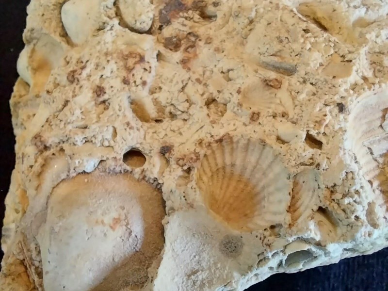
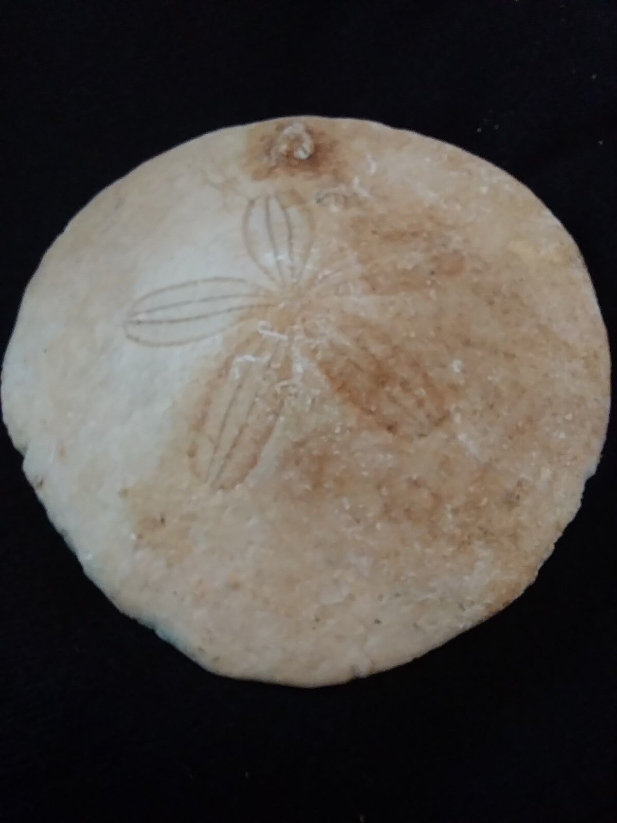
But the most interesting sight on our trip was an unassuming bluff of exposed dirt that formed one of the streambanks. The bluff rose 15 feet and showed signs of relentless scouring from the creek. Over time, fast-moving water pushed aside the grass and soil, exposing a hoard of fossils in the bank of the creek. I pried a cookie-shaped rock loose and peered closely to find what was unmistakably a sand dollar. Other jagged rocks were embedded with clear impressions of clams and scallops.
How was it that marine fossils ended up here — more than 100 miles from any beach? It turns out the answer is linked to the region’s ancient past. About 100 million years ago, the planet looked quite different. The continents were mostly in their current positions. But much of what is now the United States was underneath the sea. At that time, the Gulf of Mexico spilled north from its current position, flooding most of Texas, and formed a shallow sea that extended northward into the Great Plains and Canada. The sea’s western shore lapped the Rocky Mountains and its eastern tides reached Missouri.
The white sand beaches of the Gulf Coast were 125 miles inland from their present position, reaching what is now Columbus, Macon and Augusta. The line connecting this historic beachfront is still apparent today. Known as the Fall Line, the boundary marks the transition from Georgia’s red-clay, hilly Piedmont region in the north, to its sandy flat Coastal Plain region in the south.
By 30 million years ago, the inland ocean began receding toward its present location and began to accumulate shells, skeletons and calcium-rich marine debris as they were shucked from ancient sea life. Over time, the shells I held were compressed with others by the weight of the ocean and consolidated into a limestone bedrock.
The significance of limestone formed from this event may seem relegated to the past, but it affects us daily in big and small ways. Limestone, which underlays much of our soil, is easily eroded, and — much like a sponge — is filled with cracks, fissures and pores. This permits limestone to store substantial volumes of ground water. Limestone leads to rich aquifers and abundant water in our region that allows farmers to irrigate thirsty crops like peanuts, pecans, and cotton — fueling our agricultural industry.
The soft, easily erodible limestone also can form sinkholes, depressions and other interesting features. The Flint River and its tributaries, for example, are pocked with “blue holes” where cool, clear water surges from belowground aquifers, pouring into the creek above. As you drive past agricultural fields, if you look closely, you will see many are interrupted by small wetlands that appear as wooded oases in a sea of otherwise tilled soil. The isolated wetlands occur when limestone erodes to form a low spot that collects water for much of the year. When left intact, the wetlands can host many endangered plants and animals.
If you live in an area that draws on ground water, you can even blame erodible limestone for the white scum you scrape from your showerhead as ions from the ancient limestone are delivered daily to your tap in the form of calcium ions dissolved in the hard water.
Once the ancient sea receded, it left behind the flat topography of the Coastal Plain, where we live today. With only minute changes in elevation, rainfall made its way to the Gulf and carved many meandering waterways and creeks.
Seth and I dipped our oars back into the water. As we paddled away from the timeworn bluff, I was grateful that the ancient sea left behind such interesting creeks, and I was eager to find more of them to explore.

Author

Related Articles

New commander takes helm as Marine Corps logistics adapts to evolving battlefield
Brig. Gen. Kevin G. Collins assumed command of Marine Corps Logistics Command during a change of command ceremony at Marine Corps Logistics Base Albany, succeeding Maj. Gen. Keith D. Reventlow after four years leading the organization responsible for sustaining Marine forces around the globe.

Classifieds – July 2, 2026
Cemetery lots for sale: 5 burial plots in Riverside Cemetary… Health: Private Caregiver…Full-Time Job: Irrigation Tech needed…

Albany Herald – July 2, 2026
Dougherty schools prepare for bell-to-bell… From Ledo to Coston, Lee County’s summer road… Lee County moves another step closer to issuing…