
EF2 tornado last week in Quitman County confirmed
National Weather Service says twister had peak 115 mph winds
From Staff Reports
ALBANY — Weather officials have confirmed that one strong tornado touched down in the northern edge of Southwest Georgia during Wednesday’s storms.
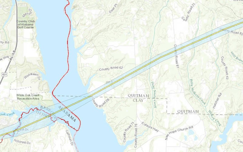
The tornado, rated EF2, touched down in Barbour County, Ala., at 11:39 a.m. Wednesday and traveled northeast 10.38 miles, lifting at 12:04 p.m. about a mile northwest of Hatcher in Georgia’s Quitman County.
Officials with the National Weather Service said the twister packed winds up to 115 mph and had a maximum width of 1,140 yards — more than three-fifths of mile wide. There were no fatalities or injuries reported.
Weather Service officials said it was the southernmost tornado to form from the powerful storms that had much of Georgia under a tornado watch that day.
According to NWS reports, the tornado touched down in the White Oak community in southeast Barbour County, producing EF1 (wind speeds 86-110 mph) damage on White Oak Drive and moving into Henry County, Ala., where it produced mostly EF1 damage across the entire width of the neighborhood between Sandy Creek and White Oak Creek. One double-wide manufactured home was shifted about 8 feet with its 2- and 3-foot anchors pulled from the ground, which weather officials said justified classifying the twister as EF2 (111-135 mph) at that point.
The tornado crossed the Walter F. George Reservoir into Georgia with EF1 damage on the eastern shore of the lake along County Road 28, coming ashore at the Quitman-Clay County line and producing damage in both counties, primarily in the form of uprooted trees that damaged several homes.
The tornado continued northeastward across rural Quitman County hitting at farm on Self Road, where weather officials noted it did significant damage to the roof of a well-constructed brick home, removing the majority of the roof. The walls of a brick outbuilding collapsed. There were also numerous trees snapped or uprooted adjacent to the home, two of which were debarked. NWS officials said the damage was consistent with what would be expected with an EF2 tornado with winds of 115 mph.
Just northeast of the farmhouse, an irrigation pivot was toppled with the northern portion falling toward the southwest and the southern portion falling in the opposite direction. The tornado continued northeast across more rural areas, causing EF1 damage to trees on County Road 82 before lifting, NWS officials said.
The storm system was the second of two strong systems that moved through the region and state last week, coming less than 48 hours after the first one. While there were a number of toppled trees in the metro Albany area from the storms, including damage to homes, no other tornadoes have been confirmed.
While Southwest Georgia has had its share of stormy weather so far in 2017, this week leading into Easter is promising to be a quieter one. The NWS forecast for Albany calls for mostly clear skies with little chance of rain through the work week. Highs are start out around 80 degrees Monday, warming to 85 on Friday, with lows ranging from 56 to 61 over that span.

Related Articles
Congress weighs packaging bill with implications for Albany manufacturers
A congressional hearing this week on proposed national packaging-labeling standards could have implications for several of Southwest Georgia’s largest manufacturers, many of which produce or package products shipped across state lines.

Dougherty County Sheriff’s Office, GBI investigate inmate death
“The sheriff’s office will conduct an administrative investigation to determine if the staff response was appropriate. We have requested that the GBI conduct an investigation.”

Dougherty Jail graduates first class of female GED recipients
“It was an escape. I can say this has been challenging. I want to express my gratitude for being able to attend this program.”
