Storm brewing in Gulf could impact region
Tropical Depression Nine could track toward Southwest Georgia
By Brad McEwen
ALBANY — Even though the immediate future of “Tropical Depression Nine” is still uncertain, weather forecasters say Albany-area residents should keep a close eye on the storm for the next few days.
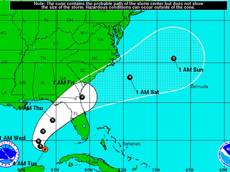
According to Mark Wool, a meteorologist with the National Weather Service office in Tallahassee, Fla., the storm, which the National Hurricane Center categorized as a tropical depression Sunday afternoon, is currently approaching the coast of Florida from the southwest. If it stays on its current track, it is expected to make landfall on Thursday as a tropical storm.
Despite that prediction, Wool said it was too early to tell exactly where the storm would hit, saying that practically the entire Florida Gulf Coastline is at risk.
“There’s still quite a bit of uncertainty,” he said. “Based on current information, it should make landfall Thursday around the Cedar Key area. But that could change. It could be anywhere from Pensacola to Tampa.”
Wool said Southwest Georgia was on the “western fringe of the cone of uncertainty,” meaning that if the storm shifts more toward the east as it heads north, Southwest Georgia would see little impact. But if the storm turns slightly west, there’s a good chance the Albany area would receive plenty of wind and rain.
“The envelope of possibilities could bring it into Southwest Georgia,” said Wool. “If there’s a western shift, that’s worse for Southwest Georgia. If it shifts east, it might not be so bad. We’d be on the fringes of the weak side of the storm. It’s certainly close enough that everybody needs to keep an eye on things up there.”
Wool said current predictions indicate the storm’s wind speed should be around 65 miles per hour when it makes landfall, which, if that holds true, would mean the storm would reach land as a tropical storm. However, Wool said, the storm could potentially intensify to hurricane strength.
“That wind speed would be at the high end of tropical storm force, and hurricane force is 74 (mph) so it’s within 10 miles per hour of hurricane winds,” he said.
Due to other atmospheric conditions, such as strong upper level winds or wind sheer, the storm could potentially remain a depression and eventually weaken as it makes its way to land later in the week, said Wool.
“The most likely scenario is that it will be a decent tropical storm (when it makes landfall),” he said.
Wool suggested that, despite the uncertainty, South Georgia residents need to monitor NWS reports in the coming few days.
“We do like to get the watches out 48 hours ahead of time, so that would be Tuesday,” said Wool.
Wool said any warnings would come out roughly 24 hours ahead of an expected event.
Related Articles

James Rubino installed in new role at Marine Corps Logistics Command in Albany
James L. Rubino recently assumed the role as executive deputy of Marine Corps Logistics Command in Albany. In his new role he will oversee integrated logistics support.

Rain depresses voter turnout in Dougherty County
“A lot of people don’t vote when it’s raining. People don’t do a lot of things when it’s raining.”
City of Albany faces shortfall for police, fire salaries
“We can’t tell staff to hire more police officers and then complain at what it costs.”