This week will feel like spring is in the air in metro Albany
Temperatures will run about 15-20 degrees higher than normal this week
By Jim Hendricks
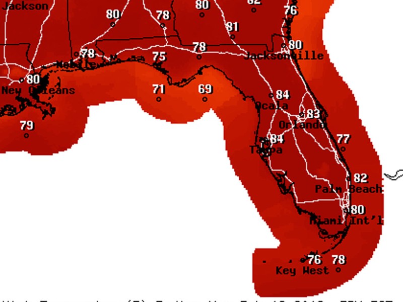
ALBANY — Spring hasn’t sprung, but it will feel like it this week, according to the National Weather Service’s forecast for the metro Albany area.
Temperatures are expected to run about 15-20 degrees warmer than normal, with the forecast posted Sunday also calling for rain chances Tuesday afternoon through Wednesday. Highs for the week are anticipated to reach 80-81, well above the 66 normal for this time of year. Lows are projected to only reach as far down as 60, about 20 degrees higher than normal for this time of year.
A cold front forecast to develop to the west of the region is expected to stall Tuesday, NWS meteorologists said.
“Scattered showers and isolated thunderstorms will be possible Tuesday afternoon ahead of the stalling front, with the highest chances in southeast Alabama and the western Florida Panhandle,” NWS meteorologist Katie Nguyen said in the forecast discussion. “Temperatures will continue to be above normal.”
Rains chances Tuesday and Wednesday were expected to be 20-30 percent.
February already has been a wet month, with 4.7 inches recorded at Southwest Georgia Regional Airport by Saturday. That was more than 1.5 inches above normal and had the year-to-date rainfall deficit cut to about a half-inch.
Rain chances should dry up for the second half of the work week.
“Although the front will gain a little bit of eastward momentum mid-week, it is expected to decay Thursday night before crossing our area,” Nguyen said. “Scattered showers and isolated thunderstorms will remain possible through Wednesday night, then will lower as the front starts to decay.
“Highs will be in the low 80s through the week and lows will be in the low to mid-60s.”
The work week should end on a dry note, with the next chance of rain coming Saturday, the forecast said.
Related Articles
DOT says delay in Oglethorpe Bridge opening should be brief
“We know it’s not going to be July 22. We don’t think it’s going to be much later than that.”

City of Albany has big July 4 celebration planned for Saturday
“It’s going to be a lot of moving and shooting them off in a short time. It’s going to be a big show.”

Brie’s Gift offers a helping hand for families affected by leukemia
“I think that would be beautiful. Brie loved her school, she loved her city. I think that would be wonderful.”