Tropical Storm Hermine gathering strength
Storm is expected to move through Georgia well east of metro Albany
By Jim Hendricks
ALBANY — Metro Albany isn’t expected to take the brunt of the storm when Tropical Storm Hermine hits land Thursday, but forecasters say the area should get rain and wind gusts, and that residents should remain alert.
“Right now, the forecast (for the Albany area) is for about 2 to 4 inches (of rain),” Kelly Godsey, a meteorologist with the National Weather Service office in Tallahassee, said Wednesday afternoon. “There’s about a 30 percent chance of tropical force gusts in Albany.”
That rain amount could jump to 3-5 inches with higher wind gusts, he said, “If the track were to shift just a little bit” to the west. “But our biggest threat is down a little bit and east, Valdosta and Tallahassee,” he said. “But all it takes is a shift of about 30 to 40 miles. … We don’t want to let our guard down just yet.”
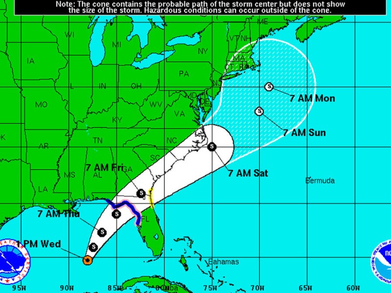
On Wednesday, the Atlantic hurricane season’s ninth tropical depression was upgraded to a named event, Tropical Storm Hermine, with wind speeds of 40 mph. The storm was expected to continue strengthening. In their situation overview Wednesday, officials with NOAA’s National Hurricane Center said there was uncertainty as to what the intensity of Hermine would be when it hit Florida’s Big Bend sometime Thursday evening, and that it was possible that winds could exceed 73 mph, which would make it a category 1 hurricane.
There were no tropical storm warnings in Southwest Georgia, but there were tropical storm watches in effect for Colquitt, Grady, Decatur, Thomas, Berrien, Cook, Lowndes, Berrien and Lanier counties.
Wednesday afternoon’s projected track had the center of the storm well south and east of metro Albany.
“The potential impact well away from the center is still pretty good,” Godsey said. “We are concerned about the potential of heavy rainfall. You do have to be concerned about the roads.”
If the projection holds true, metro Albany will be on the western side of the storm, which would make the threat of tornadoes spun off from the storm “minimum to non-existent,” he said. The greatest risk for tornadoes with Wednesday afternoon’s projection would be east of a line from Apalachicola in Florida to Adel in Georgia.
The projection had the storm moving out to the Atlantic and then moving northward off the East Coast.
“We do think it’ll be out of the region by Friday afternoon,” Godsey said.
This is historically the most active period of the Atlantic hurricane season, which started June 1. The storm season continues through Nov. 30.
Related Articles

James Rubino installed in new role at Marine Corps Logistics Command in Albany
James L. Rubino recently assumed the role as executive deputy of Marine Corps Logistics Command in Albany. In his new role he will oversee integrated logistics support.

Rain depresses voter turnout in Dougherty County
“A lot of people don’t vote when it’s raining. People don’t do a lot of things when it’s raining.”
City of Albany faces shortfall for police, fire salaries
“We can’t tell staff to hire more police officers and then complain at what it costs.”