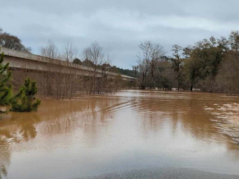
Watching the river run
Staff Photo: David Dixon
By David Dixon
[email protected]
ALBANY — Heavy rains in our watershed usually mean high water on the river, creeks and lakes. People who live, work or have interest in these levels always ask “How high will the water get?” There is no easy answer to that question due to a number of factors.
Every potential flood event is different. You have to factor in how much rain fell, where it fell and how quickly it fell. There is also the factor of how saturated the ground is, how full the aquifers are beneath the surface, how high the current levels of the water bodies are already, and elevation of the property of concern. Historical information by the property owner also can play into a prediction.
There are a number of prediction tools people use: Some of them old-fashioned, some of them quite sophisticated. A homemade stick with measurements on it or marks on a tree or foundation have been used (and some still are) to measure water levels. Counties and cities also have flood zone maps that can be referred to, but these need to be kept up to date to be truly helpful. The stick or mark is useful, but only if you check it frequently. Some events you have time to prepare for, but some happen quickly.
Today we have a more generally useful tool – the gauge. Over the years, United States Geological Survey level gauges have been placed on rivers, lakes and creeks throughout the state. Among other useful information, the gauge collects water level. The National Weather Service collects this data and issues real-time reports on those levels. The published information can be accessed by professionals like Emergency Management and dam operators to make decisions on the severity of a particular event. This date is posted online as the Advanced Hydrological Prediction Service.
The gauges are strategically located along waterways. It becomes a matter of finding the gauge or gauges nearest the property and watching the levels as the event unfolds. In our area of the watershed on the Flint River, the most often used gauges are the downtown Albany gauge, the Oakfield gauge (on Georgia 32) and the Newton gauge (on Georgia 37). It is also helpful to use the Lake Blackshear gauge and the Montezuma gauge above it.
On the Muckalee Creek we have two useful gauges: Forrester Road and Georgia 195. On the Kinchafoonee, there are three useful gauges at Preston, Pinewood Road and Century Road.
Gauge-watchers don’t just include property owners. Anglers, paddlers and water pleasure craft operators use them to see if conditions are safe enough for their planned activity.
We also have two dams in our area that can affect downstream flow. Lake Blackshear’s Crisp County Power Commission Dam has the ability to help manage the flow of water by lowering the lake level prior to the event (if there is time) and then releasing water in a regulated manner. Since the dam is a hydro-power facility, it operates under the Federal Energy Regulatory Commission, which allows officials to drop lake levels as much as 6 feet or more as needed. This ability to operate with a great deal of latitude can help moderate flood conditions greatly, as with the recent Feb. 12 event.
There is also the Georgia Power Dam on the Flint that created the Lake Worth/Chehaw complex. As a power dam, it also operates under a FERC license; however, its operation is limited by that license to only raise or lower the water plus or minus 1 foot. The Flint River Hydro facility is a “run of river” dam.
What comes in gets passed downstream. The reservoir is about 1,400 acres and has a maximum depth of 20 feet at best. Compared to Lake Blackshear, which is 8,400 acres with a maximum depth of 47 feet, one can see the size difference is large. Additionally, Lake Chehaw is heavily silted and now provides much less water holding capacity than in previous years.
Neither the Flint River dam nor the Crisp County dam are flood-control structures, but they can and do make a difference when operated in conjunction with each other. That is why it is necessary that officials communicate continually with each other during high-water events and other maintenance or emergency situations.
In our area a small group of folks banded together to discuss and share every high-water event to learn as much as we can from each other. This group was formed by Marla Edmonds about five years ago. Called the “Water Flow Concerns Group,” it consists of water-front home owners, water professionals and other concerned citizens doing what good neighbors do: help each other as much as they can with predicting what might happen.
Floods will happen. Minor floods in the winter, that have little, if any, effect on homes and property, will still have high, fast, cold water. Being on or near the water when this occurs can sometimes have tragic results. Even in the best of situations, water can be dangerous. During flood events, the danger is multiplied.
All these tools, predictions, and operational strategies can be most helpful to manage minor or moderate flood situations, but as we learned in 1994, sometimes we just need to move out of the way and let the water do what it will do.
Author

Related Articles
Regional catering business finds new home at Warrior Creek Mercantile
For months, Marchbanks said she had been asking God for an opportunity to serve others. “I just kept praying, ‘God, use me as a servant,'” she recalled. “I didn’t care what it was. I just wanted to be used to help people.”
Houston, Ford advance in contentious Lee County school board race
According to unofficial election results, challenger George Parrish Houston led the three-candidate field with 534 votes, or 42%, followed by incumbent Donna Ford with 478 votes, or 37.6%. Candidate Lavendra Shootes received 261 votes, or 20.5%.
RecX to bring outdoor equipment, activities to Moultrie during three-day show
“We’ll have the latest four-wheelers, side-by-sides … Kawasaki, Honda, Polaris and more/ There will be small recreational land management equipment from Kubota, Koyote, Mahindra. There will be a lot of different things … campers, just a lot going on.”