Cooler weather expected after midweek in Southwest Georgia
After some rain Wednesday and Thursday, temps should get seasonable
By Jim Hendricks
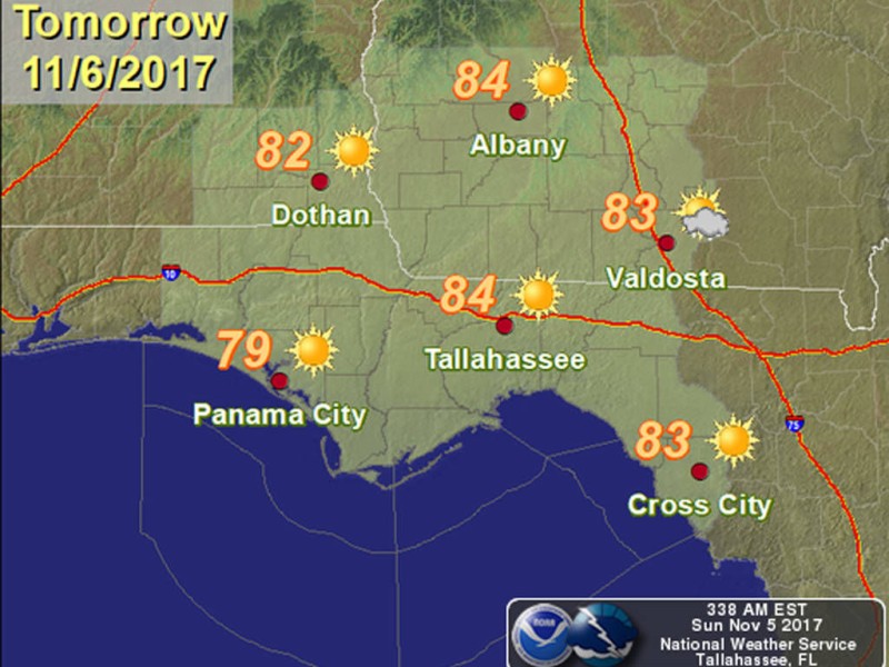
ALBANY — The work week will start out dry with above-normal temperatures before a midweek cold front passes through, bringing chances of rain and leaving Southwest Georgia with more seasonable temperatures, according to National Weather Service forecasts Sunday.
The high Monday, under sunny skies, is expected to reach 84, with a low around 61. Similar conditions will prevail Tuesday with a high of 83 and a low of 63, though cloudiness will settle in during the evening.
Midweek likely will be wet, with chances of rain at 40-50 percent Wednesday and Thursday as the cold front pushes through the area.
In the short-term forecast discussion for the NWS office in Tallahassee, meteorologist Katie Moore said high pressure over the area will being to weaken Tuesday as a front moves through from the Tennessee Valley. She said conditions are expected to stay dry Tuesday. “Both high and low temperatures will continue above normal with highs in the low to mid 80s and lows in the upper 50s to lower 60s,” Moore said.
In the long-term forecast, meteorologist Jessica Fieux said conditions will begin to change Tuesday night, with the cold front stretched across the Southeast but north of the Southwest Georgia region on Wednesday. Precipitation values could reach 1.5 inches in the area with an increase of moisture ahead of the front.
Fieux said that “rain chances will begin increasing on Wednesday, however the best chances will be Wednesday night and Thursday.”
Wednesday will be slightly cooler with a high of 81 expected, but the high Thursday is forecast to fall 11 degrees to 70. Thursday night’s low also will be close to 10 degrees cooler than Wednesday night, dropping from 59 to 50.
Normal temperatures for this time of year in Southwest Georgia are highs in the mid-70s and lows at or just below 50.
Fieux said that while temperatures “will cool behind the front, a few showers may linger into Friday. Highs will reach into the low to mid 80s on Wednesday however decrease into the upper 60s to mid 70s late in the week into the weekend behind the front. Lows in the lower 60s will decrease into the upper 40s to mid 50s late in the week.”
The early forecast for Veterans Day on Saturday calls for a high around 70 and a 20 percent chance of rain.
Related Articles
Albany Herald – June 23, 2026
Phoebe electrophysiologist reaches Advanced… Albany police officials offer update… James Rubino installed in new role at…

Classifieds – June 23, 2026
ALBANY HERALD CLASSIFIEDS JUNE 23 2026

Albany police investigate suspicious Sunday death
A 21-year-old Turner Job Corps student who was found unresponsive on Sunday evening was later pronounced dead at Phoebe Putney Memorial Hospital. The death is under investigation.