
Hurricane Irma shift places Albany in its crosshairs
Gov. Deal adds Dougherty, Lee to 94-county state of emergency list

Doug Koch, of Gainesville, Fla., relaxes at the Exchange Club fairgrounds on South Westover Boulevard on Friday. The fairgrounds opened to Florida evacuees this week and about 40 RVs had arrived by Friday. Skip Nichols with the club said he expects a large number to arrive Saturday. (Staff Photo: Terry Lewis)
By Terry Lewis
ALBANY — Hurricane Irma moved slightly westward Thursday night, placing the entire state of Georgia in the projected track of the category 4 hurricane that has slashed its way northwest across the Caribbean and is now taking aim at the Florida peninsula.
That track change also placed Albany in the bullseye for the center of the storm, which was hitting Cuba Friday afternoon and is expected to make landfall on the Florida coast early Sunday morning.
“I think when the storm reaches Southwest Georgia, it will bring tropical storm-force winds,” Jeanie McDermott, a meteorologist with the National Weather Service in Tallahassee, said Friday. “According to the current track, the best chance for that will be in the southeast part of the state, but that could change because there is a lot of uncertainty in a forecast that’s still a few days out. There is still a small chance of hurricane-force winds.
“This far out, that’s not unusual. That is why we have a ‘cone of uncertainty.’ But the closer the storm gets, the narrower the cone gets and we have more certainty in the forecast.”
McDermott said Irma should continue to degrade as it moves inland, with the center reaching Albany sometime Monday afternoon. She added that if the forecast holds up, the region could see sustained winds of up to 40 mph and 2-4 inches of rain.
According to the latest report Friday from the National Hurricane Center, the eye of the storm was located near Cuba and Irma was moving west-northwest at nearly 14 mph. That motion was expected to continue Saturday with a decrease in forward speed. A turn toward the northwest is expected by late Saturday.
On the forecast track, the eye of Irma should move near the north coast of Cuba and the central Bahamas Friday and Saturday, and be near the Florida Keys and southern Florida Sunday morning. Landfall is expected to be around 8 a.m. Sunday.
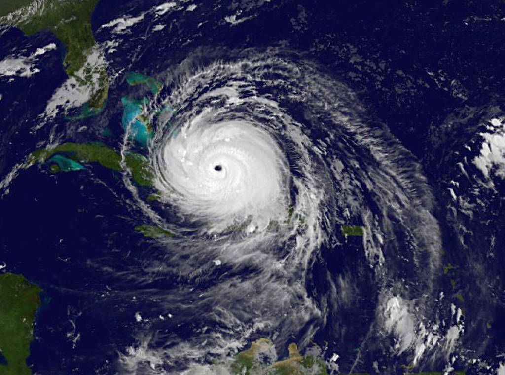
Maximum sustained winds are near 150 mph with higher gusts, forecasters say. Wind speeds are expected to drop after the storm makes landfall in Florida. Some fluctuations in intensity are likely over the weekend, but Irma is forecast to be a powerful category 4 hurricane when it reaches Florida.
Thursday night’s change in track was enough for Dougherty County Commission Chairman Chris Cohilas to declare a state of emergency Friday, prompting the Monday closure of the Dougherty County School System, along with Albany State University and Albany Technical College. Many Southwest Georgia schools — including all in metro Albany — announced that they will be closed Monday.
Friday morning, Georgia Gov. Nathan Deal added metro Albany to the growing list of counties on Georgia’s state of emergency list, which had included 30 east Georgia counties. At a news conference, Deal said Irma could be more devastating to Georgia than last year’s Hurricane Matthew.
Southwest Georgia counties added to the state of emergency list Friday include Baker, Ben Hill, Calhoun, Colquitt, Crisp, Decatur, Dougherty, Early, Grady, Lee, Lowndes, Miller, Mitchell, Randolph, Sumter, Terrell, Thomas, Tift and Worth. The additions brought the list of counties under a state of emergency to 94.
“This is considered an extremely dangerous, category 4 hurricane, with winds of more than 150 miles per hour,” Deal said. “We all remember the tremendous levels of destruction from Hurricane Matthew, and this one has the potential to be even more devastating to our state.”
On Thursday, Deal activated 5,000 National Guardsmen to be on call, adding that it is “very likely” that number could be expanded.
In Albany, the approaching storm, coupled with refinery shutdowns in Texas from Hurricane Harvey, rattled some motorists and led to rumors of gasoline supplies running out.
“I know we have two trucks out now delivering gas,” Woodall’s convenience stores’ John Woodall said. “So far, the problem hasn’t been us getting gas, it’s just the sheer volume of people we have in town right now.
“We’ve got a lot of people from Florida, and we’ve never had to deal with that before. We’re OK right now, but you can never tell. We’re winging it, like everybody else right now.”
Albany Convention & Visitors Bureau Director Rashelle Beasley said Friday afternoon she estimated nearly 4,000 Floridians were in town seeking shelter from the storm, adding that number could top out at 5,000 by Saturday night. Every hotel room in the city is booked, Chehaw’s RV park is full and evacuees and RVs were still pouring in Friday at the Exchange Club Fairgrounds on Westover Boulevard.
Related Articles
Putting on the Ritz: The rise, fall and renewal of Albany’s Harlem District
On July 7, the Albany City Commission unanimously approved final construction drawings for a comprehensive restoration of the Ritz Theatre and Cultural Center, clearing the way for the project to move into competitive bidding after years of planning and preservation efforts. The decision marks the latest chapter in a decades-long effort to preserve one of Southwest Georgia’s most significant African American landmarks.

Albany City Commission set to vote on skate park funding
“There have been other sites discussed. Based on information (from) the community, we decided on the current site. That’s the only site we’re looking at right now.”

Food, mini menagerie provide inspiration for Mitchell County’s Lydia Griffin
“I would like to open, like, a Caribbean/tropical buffet where everybody can eat anything and everything. If I can’t do that, I would start small with a coffee shop (and) deli and keep going.”
