Severe weather again threatens Southwest Georgia
Four Good Samaritan shelters opened Saturday while severe weather threatened Southwest Georgia
By Jennifer Parks
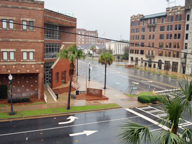
ALBANY — While still rattled by a strong storm system on Jan. 2, Southwest Georgia faced another weather threat this weekend thought early on to have the potential to be just as significant as the one that damaged countless homes and vehicles nearly three weeks ago.
Several area counties, including Dougherty County, were under severe thunderstorm warnings and tornado watches through mid-afternoon Saturday as a wave approaching storm systems posed the threat of severe weather. In response, the Dougherty County Emergency Operations Center (EOC) was up and running Saturday, and, among its many tasks, was putting the word out to those facing the storm without reliable shelter.
Wind and heavy rain arrived in the area around midday, causing concern for many residents fearful of a repeat of the events of Jan. 2. Although there were some power outages and spots of flooding, the impact from Saturday afternoon’s weather appeared to be minimal and emergency crews were able to handle any issues.
While Dougherty County Emergency Management Agency Director Ron Rowe said crews were able to respond to any issues that cropped up during the day Saturday, he did say that three homes that were not affected by the storm nearly three weeks ago, one on the 600 block of Gaines Avenue and two on the 600 block of Harmon Avenue, were damaged by trees.
Earlier in the day, EMA officials had also sent warnings telling people to avoid the Broad Avenue underpass and Broadway Street due to flooding. Road blockages due to downed trees were reported at Third Avenue and Dawson Road, Spring Flats Road west of County Line Road and the 400 block of Mud Creek Road.
Later in the day, flash flooding was reported between the 400 and 700 blocks of West Oglethorpe Boulevard, and Mud Creek Road was ultimately cleared and deemed safe for travel.
“Any issues we had were attended to immediately and resolved as fast as possible,” Rowe said. “We had a few roads blocked, some power outages, some traffic signals out, but we had a quick response and solved those issues quickly.”
Despite making it through the day mostly unscathed residents were still on alert as more inclement weather was expected later Saturday night.
Officials with the National Weather Service in Tallahassee reported ahead of the storm that the best chance for the “strongest and most widespread” severe weather, including strong winds and possible hail, would be late Saturday night into Sunday. A total widespread average rainfall amount of 2-4 inches was expected, with isolated amounts of up to 6 inches.
In reaction to the weather reports shelters were opened around the community, including four Good Samaritan shelters at East Albany Church of God at 216 Pine Bluff Road, Raleigh White/New Seasons at 2804 Philips Drive, Albany Family Worship Center at 3024 Kensington Court and Cutliff Grove Baptist Church at 835 W. Broad Ave. Those shelters are expected to remain open through today.
Many in the area were still feeling the impacts of the Jan. 2 storm on Saturday, and with strong wind gusts and hail expected to add insult to injury for those whose homes are still damaged from the first event, Rowe reminded residents to be on alert until the weather systems pass through the area.
“The last time (on Jan. 2), we had a slight risk,” said Rowe. “This time, we are enhanced.”
Rowe stressed the importance of stocking up an emergency kit to include extra batteries, water, non-perishable food items and a communication plan for touching base with loved ones once a storm passes.
“Prepare for the worst, and hope it doesn’t happen,” he said.
The EMA chief also said residents should keep an eye on the Dougherty County EMA Facebook through the weekend as additional updates will be posted there as the situation develops.
As of 6:15 p.m. Saturday the most recent update on that Facebook page reported that the severe storm risk level for “a small part of the Florida panhandle, all of southeast Alabama and a portion of southwest Georgia” was moderate. That risk level also included a 15 percent risk of tornadoes which is a higher risk than usual.
The NWS said the severe weather risk will end from west to east beginning early Sunday afternoon across southeast Alabama and the western Florida panhandle, with the threat exiting the region entirely by late afternoon.
The Albany forecast from NWS for Sunday calls for showers and the possibility of severe thunderstorms with a high in the low 70s and gusts as high as 25 mph. Chance of precipitation is expected to be 80 percent, with new rainfall amounts between three-quarters of an inch to one inch.
For those needing assistance, the 24-hour EOC can be reached at (229) 483-6226, (229) 483-6227 or (229) 483-6228.
— Brad McEwen contributed to this story
Related Articles

Georgia’s school funding formula still ignores poverty; educators say students pay the price
During a report to the board on the outcomes of this year’s legislative session, Dyer discussed the district’s efforts to persuade lawmakers to add an “opportunity weight” to Georgia’s Quality Basic Education (QBE) funding formula — a change supporters say would provide additional state funding for students living in poverty.
Red light violations will bring citations at a dozen Albany intersections
“That was always the goal of the school zone cameras, to change the behavior. It’s the same with the red lights, we want to change the behavior. When you see a yellow light, you need to slow down and prepare to stop.”

Dougherty Commission considers $104 million budget for 2026-2027 budget year
“The other side of the coin is you could have higher revenues than projected. We’re very conservative in budgeting revenues. That also reduces the need to use fund balance”